
On 7th January 2015, less than a month after the oil spill in the Sundarbans, the Bangladeshi government announced the largest unbroken mangrove forest in the world re-open to commercial, hazardous, shipping traffic. Oil tankers, however, were banned from plying thru the Sundarbans.
That ban has now been lifted. Oil tankers will once more plough through the mangroves.
“Mobile bombs,” a professor of Bangladesh University of Engineering and Technology termed these vessels – bombs waiting to explode.
And explode they did.
Mishaps In The Mangroves
Here’s how events have played out in the Sundarbans in the past eight months:
September 2014: A ship carrying cement empties its cargo into the protected forests. Two weeks later, also in September 2014, a ship carrying fly ash runs aground and sinks in the Sundarbans.
December 9, 2014: The OT Southern Star -7 spills 358,000 liters of Heavy Fuel Oil into the Sela River.
December 31, 2014: The UN oil spill assessment team recommends banning oil tanker traffic through the Sundarbans.
May 4, 2015: The MV Jabal-e-Nur sinks, carrying 500 metric tons of muriate of potash, a fertilizer.
May 9, 2015: In the aftermath of the fertilizer ship sinking, the Shipping Minister Shahjahan Khan announces that ships could stop using the Sela River and Sundarbans, should the Ghasiakhali route, which is being dredged, become navigable.
BREAKING: May 23, 2015: The Bangladeshi government does an about face and declares the Sela River route through the Sundarbans open to all traffic, including oil tankers.
The Backstory
Shipping traffic from Mongla to Morrelganj and Chittagong used to ply through the Ghasiakhali river, which skirts the Sundarbans off to its east, until 2010. In 2011, the government inexplicably closed the Ghasiakhali route.
As if on cue, local politicos and goons bought up the area by the river and carved out lucrative shrimp farms. The government built embankments to protect these interests. As a result, the silt, which normally would have deposited on the banks creating and beefing up land masses, had nowhere to go.
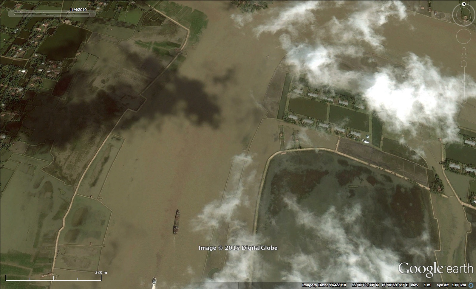
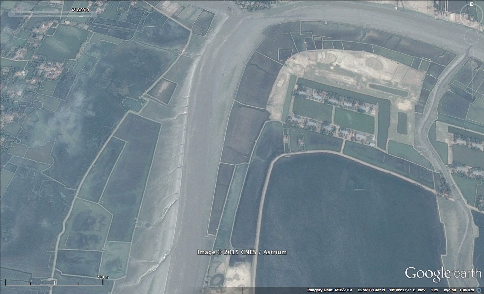
It sat in the river way and in a short few years, the Ghasiakhali route silted up (use the slider in the image above to see the difference in the river in 3 years). With Ghasiakhali choked up with shrimp farms, the ships had to find another route to the ports of Chittagong and to Morrelganj.
Going the long way around would be too heavy on business wallets. In what seems apparent in the aftermath of the oil-spill in the Sundarbans, shipping and business interests in the government have a stranglehold on decisions. They regularly swing the vane away from any environmental concerns.
Ergo, since 2011, heavy hazardous cargo has been waved right through the nearest alternative rivers — the Sela and the Passur — that cleave the Sundarbans. Over two hundred vessels of varying sizes ply through the forest everyday.
Fly ash, pesticides, sand, grain, salt, oil – laden ships plough through dolphin sanctuaries, protected habitats of crocodiles and migratory birds, economically important fishing grounds, and the last remaining home of the Royal Bengal Tiger in Bangladesh.
With a proposed thermal power plant set to come up a few kilometers upriver from the mouth of the Sundarbans, soon coal will need to be imported to the area. Without any progress in dredging the Ghasiakhali, traffic through the eco-sensitive mangroves is only set to increase.
The Importance of Being Sundarbans
See all the threats the Sundarbans faces
The Sundarbans fights hard for Bangladesh on the frontlines of climate change.
Its 6000 sq. km. of greenery and water is the buffer between Bangladesh and the “beating heart of monsoon Asia”, the Bay of Bengal.
Each monsoon season, the Bay throws storms and cyclones at the land, it rages and heaves against the shores, but the mangrove forest stands firm, resolute.
The snaking roots of the mangrove clutch the mudflats, keeping the soil from being washed away. It bears the lash of wind and surge of tide that would otherwise strike at the cities that have sprung up on its northern boundaries — cities that wear shining arrogant badges of “GDP.”
The Sundarbans is an invaluable nursery for fish and a breeding ground for shrimp, both vital for the thriving fishing industry in Bangladesh. It is a rich ecosystem that harbors and nurtures tigers and crocodiles, monkeys and man; tourists flock to gawk at its natural riches and pump money into the country’s coffers.
Mangrove forests sequester more carbon, it is said, than tropical forests – and the Sundarbans is the largest mangrove forest there is.
The Sundarbans is the main — in fact, only — defense Bangladesh has against a future that threatens rising seas and destructive monsoons. The brute force of Aila and Sidr was a teaser of what is to come, and the fact that the damage from those two cyclones was relatively contained is proof enough of the effectiveness of the mangrove buffer.
Profits to be had from these shortened shipping routes will be for naught if the Sundarbans were to die.
],[https://www.peepli.org/wp-content/uploads/2014/12/sundarbans_egrets-1000x563.jpg,(medium)],[https://www.peepli.org/wp-content/uploads/2014/12/sundarbans_egrets-1600x900.jpg,(large)])


